
Nevşehir topographic map
Interactive map
Click on the map to display elevation.
About this map
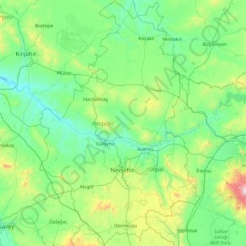
Name: Nevşehir topographic map, elevation, terrain.
Location: Nevşehir, Central Anatolia Region, Turkey (38.28120 34.23880 39.38365 35.16640)
Average elevation: 1,200 m
Minimum elevation: 847 m
Maximum elevation: 3,318 m
Nevşehir (from the Persian compound نو شهر Naw-shahr meaning "new city"), formerly Neapolis and Muşkara, is a city and the capital district of Nevşehir Province in the Central Anatolia Region of Turkey. According to the 2010 census, the population of the district is 117,890 of which 85,634 live in the city of Nevşehir. The district covers an area of 535 km2 (207 sq mi), and the town lies at an elevation of 1,224 m (4,016 ft).
Other topographic maps
Click on a map to view its topography, its elevation and its terrain.
Ballık
Ballık, Altınyayla, Burdur, Mediterranean Region, Turkey
Average elevation: 1,528 m
Bezirhane Mahallesi
Bezirhane Mahallesi, Gölbaşı, Ankara, Central Anatolia Region, Turkey
Average elevation: 1,158 m
Bıçakcılar
Bıçakcılar, Yusufeli, Artvin, Black Sea Region, Turkey
Average elevation: 1,833 m
Eskisehir
Eskisehir, Odunpazarı, Eskişehir, Central Anatolia Region, 26120, Turkey
Average elevation: 949 m
İshakçelebi
İshakçelebi, Saruhanlı, Manisa, Aegean Region, Turkey
Average elevation: 55 m
Akşemsettin Mahallesi
Akşemsettin Mahallesi, Eyüpsultan, Istanbul, Marmara Region, 34070, Turkey
Average elevation: 62 m
Camuzcu Mahallesi
Camuzcu Mahallesi, Seyhan, Adana, Mediterranean Region, Turkey
Average elevation: 13 m