
Punta Del Este topographic map
Interactive map
Click on the map to display elevation.
About this map
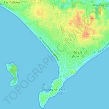
Name: Punta Del Este topographic map, elevation, terrain.
Location: Punta Del Este, Maldonado, 20100, Uruguay (-34.97393 -54.95710 -34.91285 -54.90725)
Average elevation: 10 m
Minimum elevation: -6 m
Maximum elevation: 49 m
Other topographic maps
Click on a map to view its topography, its elevation and its terrain.
Piriápolis
Uruguay > Maldonado > Piriápolis
Piriápolis, Maldonado, 20200, Uruguay
Average elevation: 31 m