Rossmore topographic map
Interactive map
Click on the map to display elevation.
About this map
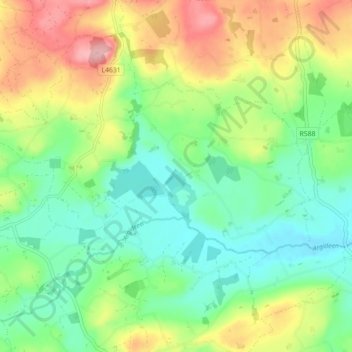
Name: Rossmore topographic map, elevation, terrain.
Location: Rossmore, West Cork, County Cork, Munster, P85 TA48, Ireland (51.64656 -9.01137 51.69180 -8.92201)
Average elevation: 93 m
Minimum elevation: 38 m
Maximum elevation: 188 m
Other topographic maps
Click on a map to view its topography, its elevation and its terrain.
Gunpoint
Gunpoint, Lowertown, West Cork, County Cork, Munster, Ireland
Average elevation: 14 m
Waterfall
Waterfall, Inishkenny, Municipal District of Carrigaline, County Cork, Munster, T12 CYF2, Ireland
Average elevation: 96 m
Kilcullen
Kilcullen, Municipal District of Macroom, County Cork, Munster, Ireland
Average elevation: 216 m
The Glen
Ireland > County Cork > Cork
The Glen, Dublin Hill, The Glen B, Cork, County Cork, Munster, T23 D437, Ireland
Average elevation: 57 m
Glenbrook
Ireland > County Cork > Municipal District of Carrigaline
Glenbrook, Municipal District of Carrigaline, County Cork, Munster, T12 KT5N, Ireland
Average elevation: 50 m
Municipal District of Cobh
Municipal District of Cobh, County Cork, Munster, Ireland
Average elevation: 98 m
Glenreagh
Glenreagh, Kilmeen, The Municipal District of Kanturk – Mallow, County Cork, Munster, Ireland
Average elevation: 229 m
Kinsale
Ireland > County Cork > Kinsale
Kinsale, The Municipal District of Bandon – Kinsale, County Cork, Munster, P17 H590, Ireland
Average elevation: 44 m
Glanmire
Ireland > County Cork > Cork
Glanmire, Cork, County Cork, Munster, T45 X924, Ireland
Average elevation: 58 m