
Donghai County topographic map
Interactive map
Click on the map to display elevation.
About this map
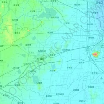
Name: Donghai County topographic map, elevation, terrain.
Location: Donghai County, Lianyungang City, Jiangsu, China (34.31440 118.39555 34.80513 119.11255)
Average elevation: 22 m
Minimum elevation: -2 m
Maximum elevation: 421 m
Other topographic maps
Click on a map to view its topography, its elevation and its terrain.
Longtan
China > Jiangsu > Qixia District
Longtan, Qixia District, Nanjing City, Jiangsu, China
Average elevation: 25 m
Xianlin
China > Jiangsu > Qixia District
Xianlin, Qixia District, Nanjing City, Jiangsu, 210023, China
Average elevation: 28 m
Chongchuan District
China > Jiangsu > Nantong City
Chongchuan District, Nantong City, Jiangsu, 226000, China
Average elevation: 4 m