
Genesee County topographic map
Interactive map
Click on the map to display elevation.
About this map
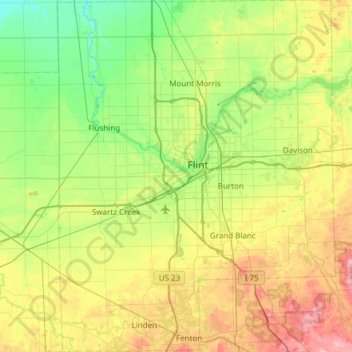
Name: Genesee County topographic map, elevation, terrain.
Location: Genesee County, Michigan, United States (42.78077 -83.93207 43.22312 -83.45330)
Average elevation: 246 m
Minimum elevation: 184 m
Maximum elevation: 370 m
Other topographic maps
Click on a map to view its topography, its elevation and its terrain.
Grand Mere State Park
United States > Michigan > Berrien County > Stevensville
Average elevation: 185 m
Stony Creek
United States > Michigan > Washtenaw County > Augusta Charter Township
Average elevation: 228 m
Charles M Taylor III Nature Preserve
United States > Michigan > Charlevoix County
Average elevation: 193 m
Sand River
United States > Michigan > Alger County > Onota Township > Sand River
Average elevation: 187 m
Pere Marquette River
United States > Michigan > Mason County > Ludington > Buttersville
Average elevation: 180 m