
Kothamangalam topographic map
Interactive map
Click on the map to display elevation.
About this map
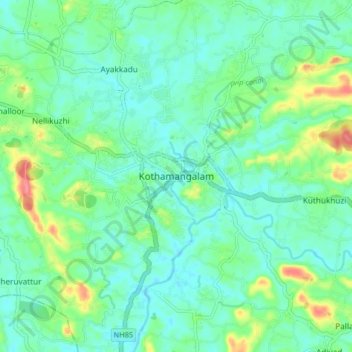
Name: Kothamangalam topographic map, elevation, terrain.
Location: Kothamangalam, Ernakulam, Kerala, 686691, India (10.02403 76.58182 10.10403 76.66182)
Average elevation: 34 m
Minimum elevation: 15 m
Maximum elevation: 90 m
Kothamangalam is situated in the eastern part of the Ernakulam district. Kothamangalam is known as the Gateway of Highrange. According to the division of the geographical regions of Kerala, i.e. High-lands, Mid-lands and Low-lands, Kothamangalam is in a Mid-land region. The general topography is hilly. The Munnar hill station is around 85 kilometres from Kothamangalam.