
Jennacubbine topographic map
Interactive map
Click on the map to display elevation.
About this map
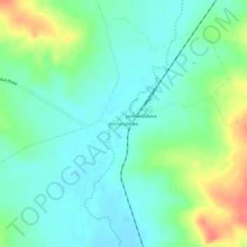
Name: Jennacubbine topographic map, elevation, terrain.
Location: Jennacubbine, Western Australia, Australia (-31.46076 116.70047 -31.42076 116.74047)
Average elevation: 196 m
Minimum elevation: 178 m
Maximum elevation: 238 m
Western Australia trails, hiking, mountain biking, running and outdoor activities
Other topographic maps
Click on a map to view its topography, its elevation and its terrain.
Cartamulligan Well Nature Reserve
Australia > Western Australia > Jennacubbine
Average elevation: 196 m