
Marshall County topographic map
Interactive map
Click on the map to display elevation.
About this map
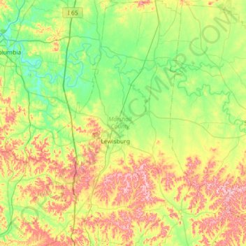
Name: Marshall County topographic map, elevation, terrain.
Location: Marshall County, Tennessee, United States of America (35.25262 -86.96093 35.71084 -86.59714)
Average elevation: 244 m
Minimum elevation: 170 m
Maximum elevation: 383 m
Other topographic maps
Click on a map to view its topography, its elevation and its terrain.
Collinwood
United States of America > Tennessee > Collinwood
Collinwood, Wayne County, Tennessee, 38450, United States of America
Average elevation: 304 m
Laurel Creek
United States of America > Tennessee > Laurel Creek
Bone Cave, Laurel Creek, Van Buren County, Tennessee, 38550, United States of America
Average elevation: 282 m
Murphy Mill
United States of America > Tennessee > Murphy Mill
Cave Spring, Murphy Mill, Claiborne County, Tennessee, 37879, United States of America
Average elevation: 463 m
Mount Juliet
United States of America > Tennessee > Mount Juliet
Mount Juliet, Wilson County, Tennessee, 37122, United States of America
Average elevation: 169 m
Parrottsville
United States of America > Tennessee > Parrottsville
Parrottsville, Cocke County, Tennessee, United States of America
Average elevation: 386 m
Richland
United States of America > Tennessee > Nashville-Davidson > Richland
Richland, Nashville-Davidson, Davidson County, Tennessee, 37209, United States of America
Average elevation: 146 m