
Dunkeld topographic map
Interactive map
Click on the map to display elevation.
About this map
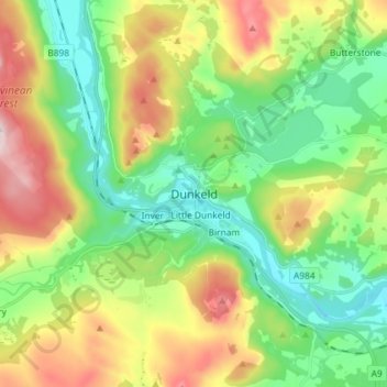
Name: Dunkeld topographic map, elevation, terrain.
Location: Dunkeld, Perth and Kinross, Scotland, PH8 0AL, United Kingdom (56.52557 -3.62625 56.60557 -3.54625)
Average elevation: 190 m
Minimum elevation: 36 m
Maximum elevation: 469 m
Other topographic maps
Click on a map to view its topography, its elevation and its terrain.
Castlehill Reservoir
United Kingdom > Scotland > Perth and Kinross > Glendevon
Average elevation: 268 m