
Kings Beach topographic map
Interactive map
Click on the map to display elevation.
About this map
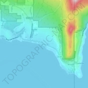
Name: Kings Beach topographic map, elevation, terrain.
Average elevation: 1,955 m
Minimum elevation: 1,894 m
Maximum elevation: 2,291 m
Other topographic maps
Click on a map to view its topography, its elevation and its terrain.
Lake Tahoe
United States > California > Placer County
Lake Tahoe is renowned for its dramatic topography, characterized by rugged mountain ranges and deep, crystal-clear waters. Nestled in the Sierra Nevada, the lake itself lies at an elevation of approximately 6,225 feet (1,897 meters) and spans about 22 miles (35 kilometers) in length and 12 miles (19…
Average elevation: 2,077 m
Roseville
United States > California > Placer County
Roseville has a hot-summer Mediterranean climate that is characterized by cool, wet, usually snowless winters and hot, dry summers (Köppen Csa). The wet season is generally October through April. Because Roseville is east of Sacramento and at a higher elevation, it receives slightly more rainfall. Average…
Average elevation: 67 m
Roseville
United States > California > Placer County
The wet season is generally October through April. Because Roseville is east of Sacramento and at a higher elevation, it receives slightly more rainfall. The dry season lasts from June to October; similar to other Central Valley cities, temperatures can be extremely hot in the summer (routinely peaking above…
Average elevation: 67 m
Folsom Lake State Recreation Area
United States > California > Placer County > Auburn
Avery's Pond is located near Rattlesnake Bar, north of the Rattlesnake Bar Equestrian Assembly Area. It can be accessed by parking at Rattlesnake Bar and walking 1.1 miles to the sites. There are 2 Sites and each holds 8 people. There are no water or garbage service and no dogs or fires allowed. It is commonly…
Average elevation: 201 m
Roseville
United States > California > Placer County
Roseville has a hot-summer Mediterranean climate that is characterized by cool, wet, usually snowless winters and hot, dry summers (Köppen Csa). The wet season is generally October through April. Because Roseville is east of Sacramento and at a higher elevation, it receives slightly more rainfall. Average…
Average elevation: 67 m
Colfax
United States > California > Placer County
Colfax has a hot-summer Mediterranean climate (Köppen Csa) that is characterized by cool, wet winters and hot, dry summers. Summers can be quite hot, especially in the months of July and August where temperatures easily reach 90 °F (32 °C), with plenty of sunshine. Winters, on the other hand, are quite cool…
Average elevation: 685 m
Lake Tahoe
United States > California > Placer County
Lake Tahoe has a dry-summer continental climate (Dsb in the Köppen climate classification), featuring warm, dry summers and chilly winters with regular snowfall. Mean annual precipitation ranges from over 55 inches (1440 mm) for watersheds on the west side of the basin to about 26 inches (660 mm) near the…
Average elevation: 2,077 m
Roseville
United States > California > Placer County
Roseville has a hot-summer Mediterranean climate that is characterized by cool, wet, usually snowless winters and hot, dry summers (Köppen Csa). The wet season is generally October through April. Because Roseville is east of Sacramento and at a higher elevation, it receives slightly more rainfall. Average…
Average elevation: 67 m
Roseville
United States > California > Placer County
Roseville has a hot-summer Mediterranean climate that is characterized by cool, wet, usually snowless winters and hot, dry summers (Köppen Csa). The wet season is generally October through April. Because Roseville is east of Sacramento and at a higher elevation, it receives slightly more rainfall. Average…
Average elevation: 67 m