
Interior Division topographic map
Interactive map
Click on the map to display elevation.
About this map
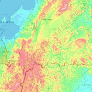
Name: Interior Division topographic map, elevation, terrain.
Location: Interior Division, Sabah, Malaysia (4.72998 116.11316 4.76998 116.15316)
Average elevation: 950 m
Minimum elevation: 683 m
Maximum elevation: 1,221 m
Other topographic maps
Click on a map to view its topography, its elevation and its terrain.
Kuala Penyu
Malaysia > Sabah > Kuala Penyu
Kuala Penyu, Interior Division, Sabah, 89740, Malaysia
Average elevation: 8 m
Gaya Island
Malaysia > Sabah > Kota Kinabalu
Gaya Island, Kota Kinabalu, Sabah, Malaysia
Average elevation: 34 m
Mount Kinabalu
Malaysia > Sabah > Kota Kinabalu
Mount Kinabalu, Kota Kinabalu, Sabah, Malaysia
Average elevation: 3,567 m