
Perm Krai topographic map
Interactive map
Click on the map to display elevation.
About this map
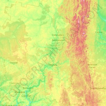
Name: Perm Krai topographic map, elevation, terrain.
Location: Perm Krai, Volga Federal District, Russia (56.03516 53.75595 61.15516 58.87595)
Average elevation: 230 m
Minimum elevation: 62 m
Maximum elevation: 1,486 m
Other topographic maps
Click on a map to view its topography, its elevation and its terrain.