
Schinnen topographic map
Interactive map
Click on the map to display elevation.
Schinnen
Dutch topographic map of the municipality of Schinnen, June 2015
About this map
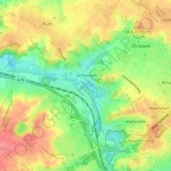
Name: Schinnen topographic map, elevation, terrain.
Location: Schinnen, Beekdaelen, Limburg, Netherlands (50.92402 5.84720 50.95570 5.91670)
Average elevation: 92 m
Minimum elevation: 57 m
Maximum elevation: 130 m
Other topographic maps
Click on a map to view its topography, its elevation and its terrain.