
Wollaton topographic map
Interactive map
Click on the map to display elevation.
About this map
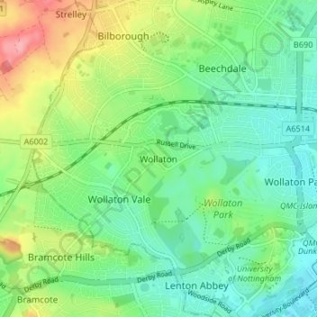
Name: Wollaton topographic map, elevation, terrain.
Location: Wollaton, Nottingham, England, NG8 2AF, United Kingdom (52.93315 -1.24043 52.97315 -1.20043)
Average elevation: 58 m
Minimum elevation: 24 m
Maximum elevation: 129 m
Other topographic maps
Click on a map to view its topography, its elevation and its terrain.
Bulwell
United Kingdom > England > Nottingham
Bulwell, Nottingham, England, NG6 8QA, United Kingdom
Average elevation: 84 m