
Belknap County topographic map
Interactive map
Click on the map to display elevation.
About this map
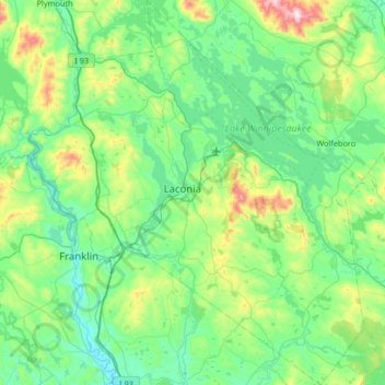
Name: Belknap County topographic map, elevation, terrain.
Location: Belknap County, New Hampshire, United States (43.28444 -71.73172 43.76098 -71.15918)
Average elevation: 228 m
Minimum elevation: 74 m
Maximum elevation: 888 m
Other topographic maps
Click on a map to view its topography, its elevation and its terrain.
The Branch
United States > New Hampshire > Cheshire County > Keene > South Keene
Average elevation: 181 m
Jenness Beach
United States > New Hampshire > Rockingham County > Rye > Rye Beach Village District
Average elevation: 5 m
Thorntons Ferry
United States > New Hampshire > Hillsborough County > Merrimack
Average elevation: 54 m
North Swanzey
United States > New Hampshire > Cheshire County > Keene > North Swanzey
Average elevation: 169 m
Waterloo
United States > New Hampshire > Merrimack County > Warner > Waterloo
Average elevation: 213 m