
Songkhla Province topographic map
Interactive map
Click on the map to display elevation.
About this map
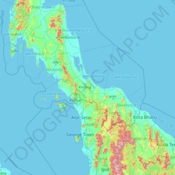
Name: Songkhla Province topographic map, elevation, terrain.
Location: Songkhla Province, Thailand (4.31902 97.98985 9.43902 103.10985)
Average elevation: 78 m
Minimum elevation: -2 m
Maximum elevation: 1,991 m
The province is on the Malay Peninsula, on the coast of the Gulf of Thailand. The highest elevation is Khao Mai Kaeo at 821 meters.
Other topographic maps
Click on a map to view its topography, its elevation and its terrain.
Hat Yai
Hat Yai, Kho Hong, Songkhla Province, Thailand
Average elevation: 47 m
Cat Island
Thailand > Songkhla Province > Songkhla
Cat Island, Songkhla, Songkhla Province, Thailand
Average elevation: 0 m