
Southern Province topographic map
Interactive map
Click on the map to display elevation.
About this map
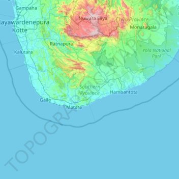
Name: Southern Province topographic map, elevation, terrain.
Location: Southern Province, Sri Lanka (5.71900 79.79310 6.58004 81.86764)
Average elevation: 136 m
Minimum elevation: -1 m
Maximum elevation: 2,453 m
Other topographic maps
Click on a map to view its topography, its elevation and its terrain.
Hambantota District
Hambantota District, Southern Province, Sri Lanka
Average elevation: 110 m
Matara
Sri Lanka > Southern Province > Matara
Matara, Matara District, Southern Province, 81000, Sri Lanka
Average elevation: 7 m
Hambantota
Sri Lanka > Southern Province > Hambantota
Hambantota, Hambantota District, Southern Province, Sri Lanka
Average elevation: 12 m