
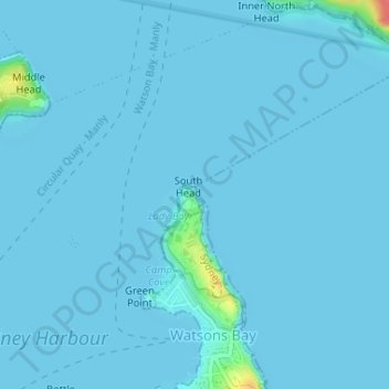
Hornby Lighthouse topographic map
Interactive map
Click on the map to display elevation.
About this map
Name: Hornby Lighthouse topographic map, elevation, terrain.
Average elevation: 2 m
Minimum elevation: 0 m
Maximum elevation: 63 m
The wing for staff quarters in an "I" plan with enclosed verandahs either side. This building probably c. 1850s building having very good ashlar work to external walls with each elevation recessed within a frame of foundation, eaves and quoin mouldings. Windows are marked by simple classical sill and lintel mouldings. The hipped roofs originally of slate are now sheeted in asbestos cement. A good timber picket fence encloses the property which is in good condition and well maintained.
Other topographic maps
Click on a map to view its topography, its elevation and its terrain.
Dangar Island
Dangar Island, Sydney, The Council of the Shire of Hornsby, 2083, Australia
Average elevation: 17 m
Carss Park
Australia > New South Wales > Sydney
Carss Park, St George, Sydney, Georges River Council, 2221, Australia
Average elevation: 15 m
Manly Lagoon
Australia > New South Wales > Sydney
Manly Lagoon, Rowe Street, Freshwater, Northern Beaches, Sydney, Northern Beaches Council, 2096, Australia
Average elevation: 23 m
Currency Creek
Currency Creek, Sydney, Hawkesbury City Council, 2756, Australia
Average elevation: 25 m
Sydney Water Supply Canal
Sydney Water Supply Canal, Sydney, Fairfield City Council, 2175, Australia
Average elevation: 82 m
Ropes Creek
Ropes Creek, Sydney, Fairfield City Council, 2175, Australia
Average elevation: 103 m
Callan Park
Callan Park, Lilyfield, Sydney, Inner West Council, 2040, Australia
Average elevation: 17 m
Badgerys Creek
Badgerys Creek, Sydney, Liverpool City Council, 2555, Australia
Average elevation: 79 m
Morrison Bay
Morrison Bay, Jetty Road, Putney, Sydney, Council of the City of Ryde, 2112, Australia
Average elevation: 18 m
Sydney Water Supply Canal
Sydney Water Supply Canal, Sydney, Campbelltown City Council, 2563, Australia
Average elevation: 110 m
Wynyard Park
Wynyard Park, Darling Quarter, Sydney, Council of the City of Sydney, 2000, Australia
Average elevation: 20 m
Russel Street Reserve
Russel Street Reserve, Strathfield, Sydney, Burwood Council, 2135, Australia
Average elevation: 25 m
Morreau reserve
Morreau reserve, Rooty Hill, Sydney, Blacktown City Council, 2766, Australia
Average elevation: 46 m
Sydney Water Supply Canal
Sydney Water Supply Canal, Sydney, Liverpool City Council, 2178, Australia
Average elevation: 74 m
Nepean River
Nepean River, Ambler Close, Emu Heights, Sydney, Penrith City Council, 2750, Australia
Average elevation: 61 m
Bold Park
Australia > New South Wales > Sydney
Bold Park, Cabramatta West, Sydney, Fairfield City Council, 2166, Australia
Average elevation: 33 m
Varroville
Australia > New South Wales > Sydney
Varroville, Sydney, Campbelltown City Council, 2566, Australia
Average elevation: 80 m
Carara Reserve
Australia > New South Wales > Sydney
Carara Reserve, West Ryde, Sydney, Council of the City of Ryde, 2114, Australia
Average elevation: 53 m
Silverwater
Australia > New South Wales > Sydney
Silverwater, Sydney, City of Parramatta Council, 2128, Australia
Average elevation: 10 m