
Mazatlán topographic map
Interactive map
Click on the map to display elevation.
About this map
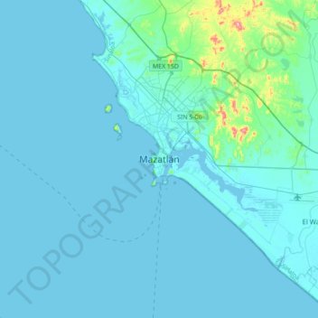
Name: Mazatlán topographic map, elevation, terrain.
Location: Mazatlán, Sinaloa, 82000, Mexico (23.07131 -106.57531 23.39131 -106.25531)
Average elevation: 25 m
Minimum elevation: -2 m
Maximum elevation: 275 m
At the edge of Mazatlán and Concordia runs the Sierra del Metate and Panuco. In this county, the Sierra Madre Occidental is diverted to penetrate Durango, leaving before some detachments, such as the Sierra de San Juan and the Friars, and constitutes, in of its topography, the following hilly areas: