Central Development Region topographic map
Interactive map
Click on the map to display elevation.
About this map
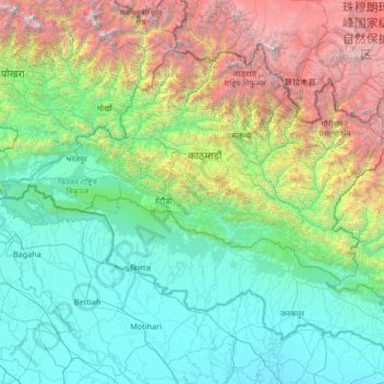
Name: Central Development Region topographic map, elevation, terrain.
Location: Central Development Region, Nepal (26.56802 83.91936 28.38583 86.57262)
Average elevation: 1,546 m
Minimum elevation: 50 m
Maximum elevation: 7,949 m
Other topographic maps
Click on a map to view its topography, its elevation and its terrain.
Mulpani Pipalbot
Nepal > Central Development Region > Mulpani Pipalbot
Mulpani Pipalbot, Kathmandu, Bagmati, Central Development Region, 97701, Nepal
Average elevation: 1,336 m
Chillime
Nepal > Central Development Region > Chillime
Chillime, Rasuwa, Bagmati, Central Development Region, Nepal
Average elevation: 2,194 m
Janakpur
Nepal > Central Development Region
Janakpur, Central Development Region, Nepal
Average elevation: 1,600 m
Gelu
Nepal > Central Development Region > Gelu
Gelu, Ramechhap, Janakpur, Central Development Region, Nepal
Average elevation: 1,030 m