
Catanduanes topographic map
Interactive map
Click on the map to display elevation.
About this map
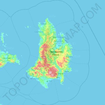
Name: Catanduanes topographic map, elevation, terrain.
Location: Catanduanes, Bicol Region, Philippines (13.38141 123.89645 14.24723 124.56309)
Average elevation: 35 m
Minimum elevation: -2 m
Maximum elevation: 789 m
The topography of Catanduanes Island is rugged and mountainous, becoming more pronounced towards the central portion of the island. Less than 10 percent of the land area has a slope gradient under 8 percent, mostly fractured and narrow strips of plains located along the coastal areas where most of the inhabitants are settled. The highest mountain peak is in Boctot, located between the municipalities of Virac and San Miguel with an elevation of 803 metres (2,635 ft) above sea level. It is the premier mountain range with broadly spread old-growth forests and watershed which exerts widespread influence over its immediate environs that include the municipalities of Virac, Bato, and San Miguel. Other prominent mountain forms include the ranges: Obi in Caramoran, Cagmasoso in San Andres, and the Summit and Magsumoso ranges within the Viga and Gigmoto areas.
Other topographic maps
Click on a map to view its topography, its elevation and its terrain.
Eastern Manila District
Eastern Manila District, Metro Manila, Philippines
Average elevation: 57 m
Malunang
Philippines > Iloilo > Zarraga
Malunang, Zarraga, Iloilo, Western Visayas, 5004, Philippines
Average elevation: 5 m
Calanipawan
Calanipawan, Tacloban, Eastern Visayas, 6500, Philippines
Average elevation: 18 m
Asisan
Philippines > Cavite > Tagaytay
Asisan, Tagaytay, Cavite, Calabarzon, 4120, Philippines
Average elevation: 526 m
San Nicolas
San Nicolas, Ilocos Norte, Ilocos Region, 2900, Philippines
Average elevation: 19 m
Lungaog
Philippines > Davao del Norte > Santo Tomas
Lungaog, Santo Tomas, Davao del Norte, Davao Region, 8112, Philippines
Average elevation: 18 m
Vigan
Vigan, Ilocos Sur, Ilocos Region, 2700, Philippines
Average elevation: 34 m
Longos
Philippines > Bulacan > Malolos
Longos, Malolos, Bulacan, Central Luzon, 3000, Philippines
Average elevation: 4 m
San Carlos
Philippines > Batangas > Rosario
San Carlos, Rosario, Batangas, Calabarzon, 4225, Philippines
Average elevation: 128 m
Wawa Dam
Philippines > Agusan del Sur > Bayugan > Wawa
Wawa Dam, Wawa, Bayugan, Agusan del Sur, Caraga, Philippines
Average elevation: 78 m
Wawa Dam
Philippines > Rizal > Wawa
Wawa Dam, Wawa, Rizal, Calabarzon, 1860, Philippines
Average elevation: 156 m
San Juan
San Juan, Batangas, Calabarzon, 4226, Philippines
Average elevation: 60 m
Balloc
Philippines > Tarlac > San Clemente
Balloc, San Clemente, Tarlac, Central Luzon, 2305, Philippines
Average elevation: 50 m
Maruclap
Philippines > Batangas > Batangas City
Maruclap, Batangas City, Batangas, Calabarzon, 4200, Philippines
Average elevation: 224 m
Baliwag
Baliwag, Bulacan, Central Luzon, 3006, Philippines
Average elevation: 16 m
Tubod
Philippines > Negros Oriental > Bacong
Tubod, Bacong, Negros Oriental, Central Visayas, Philippines
Average elevation: 127 m
Bacong
Bacong, Negros Oriental, Central Visayas, 6216, Philippines
Average elevation: 94 m
Pantar
Pantar, Lanao del Norte, Northern Mindanao, Philippines
Average elevation: 595 m
Baco
Philippines > Oriental Mindoro
Baco, Oriental Mindoro, Mimaropa, Philippines
Average elevation: 14 m
Cordillera Administrative Region
Cordillera Administrative Region, Philippines
Average elevation: 359 m
Alawa
Alawa, Abra, Cordillera Administrative Region, Philippines
Average elevation: 434 m
Javier
Javier, Leyte 5th District, Leyte, Eastern Visayas, 6511, Philippines
Average elevation: 170 m
Kidaman
Philippines > Davao Occidental > Jose Abad Santos
Kidaman, Jose Abad Santos, Davao Occidental, Davao Region, 8014, Philippines
Average elevation: 476 m
Misamis Occidental
Misamis Occidental, Northern Mindanao, Philippines
Average elevation: 180 m
Kibawe
Kibawe, Bukidnon, Northern Mindanao, 8720, Philippines
Average elevation: 267 m
Fraser Island
Fraser Island, Puerto Princesa, Mimaropa, Philippines
Average elevation: 104 m
San Enrique
Philippines > Guimaras > San Lorenzo
San Enrique, San Lorenzo, Guimaras, Western Visayas, Philippines
Average elevation: 16 m
Igdarapdap
Philippines > Guimaras > Nueva Valencia
Igdarapdap, Nueva Valencia, Guimaras, Western Visayas, Philippines
Average elevation: 33 m
Baruan
Baruan, Pangasinan, Ilocos Region, 2410, Philippines
Average elevation: 24 m
Samal Island
Philippines > Davao del Norte > Samal
Samal Island, Samal, Davao del Norte, Davao Region, Philippines
Average elevation: 35 m