
Luleå kommun topographic map
Interactive map
Click on the map to display elevation.
About this map
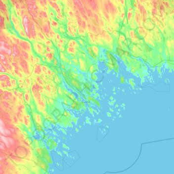
Name: Luleå kommun topographic map, elevation, terrain.
Location: Luleå kommun, Norrbotten County, Sweden (65.04128 21.33569 66.28314 23.39244)
Average elevation: 64 m
Minimum elevation: -4 m
Maximum elevation: 401 m
Other topographic maps
Click on a map to view its topography, its elevation and its terrain.
Abisko
Permafrost is common around the village albeit this low altitude permafrost is disappearing because of global warming and increased snowfall.
Average elevation: 395 m