
Cadell topographic map
Interactive map
Click on the map to display elevation.
About this map
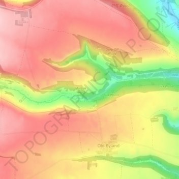
Name: Cadell topographic map, elevation, terrain.
Average elevation: 200 m
Minimum elevation: 91 m
Maximum elevation: 258 m
Other topographic maps
Click on a map to view its topography, its elevation and its terrain.
Malton
United Kingdom > England > Ryedale > Malton
Malton, Ryedale, North Yorkshire, Yorkshire and the Humber, England, YO17 7HX, United Kingdom
Average elevation: 38 m