
Koomberkine topographic map
Interactive map
Click on the map to display elevation.
About this map
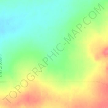
Name: Koomberkine topographic map, elevation, terrain.
Location: Koomberkine, Western Australia, Australia (-30.97820 116.95670 -30.95820 116.97670)
Average elevation: 350 m
Minimum elevation: 318 m
Maximum elevation: 388 m
Western Australia trails, hiking, mountain biking, running and outdoor activities
Other topographic maps
Click on a map to view its topography, its elevation and its terrain.
Mount Melville
Australia > Western Australia > Albany
The mount has an elevation of 152 metres (499 ft).
Average elevation: 36 m
Clackline
Clackline Bridge is a historic road bridge in Clackline that carried the Great Eastern Highway until 2008. It is the only bridge in Western Australia to have spanned both a waterway and railway, the Clackline Brook and the former Eastern Railway alignment. The mainly timber bridge has a unique curved and…
Average elevation: 286 m