
Nottinghamshire topographic map
Interactive map
Click on the map to display elevation.
About this map
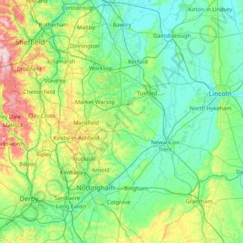
Name: Nottinghamshire topographic map, elevation, terrain.
Average elevation: 74 m
Minimum elevation: -1 m
Maximum elevation: 433 m
Other topographic maps
Click on a map to view its topography, its elevation and its terrain.
Wadworth
United Kingdom > England > Doncaster > Wadworth
Wadworth, Doncaster, Yorkshire and the Humber, England, DN11 9AN, United Kingdom
Average elevation: 41 m
Finningley
United Kingdom > England > Doncaster
Finningley, Doncaster, Yorkshire and the Humber, England, United Kingdom
Average elevation: 4 m