
Kuantan topographic map
Interactive map
Click on the map to display elevation.
About this map
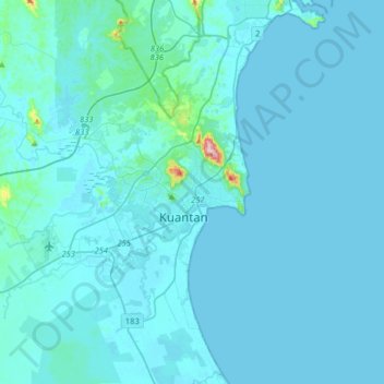
Name: Kuantan topographic map, elevation, terrain.
Location: Kuantan, Pahang, 25100, Malaysia (3.63856 103.16199 3.95856 103.48199)
Average elevation: 14 m
Minimum elevation: -4 m
Maximum elevation: 356 m
Other topographic maps
Click on a map to view its topography, its elevation and its terrain.
Cameron Highlands
Surveyed by the government geologist and explorer William Cameron in 1885, the outpost consists of three mukims (subdistricts), namely Ringlet, Tanah Rata and Ulu Telom. Its eight settlements are Ringlet, Tanah Rata (the administrative centre), Brinchang, the Bertam Valley, Kea Farm, Tringkap, Kampung Kuala…
Average elevation: 1,117 m