Town of Olive topographic map
Interactive map
Click on the map to display elevation.
About this map
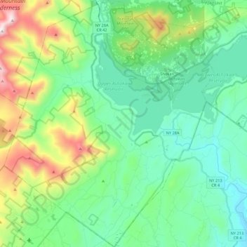
Name: Town of Olive topographic map, elevation, terrain.
Location: Town of Olive, Ulster County, New York, United States (41.86076 -74.35435 42.02106 -74.17004)
Average elevation: 344 m
Minimum elevation: 58 m
Maximum elevation: 1,159 m
Other topographic maps
Click on a map to view its topography, its elevation and its terrain.
Tillson
United States > New York > Ulster County > Town of Rosendale
Tillson, Town of Rosendale, Ulster County, New York, 12486, United States
Average elevation: 58 m
Bloomington
United States > New York > Ulster County > Town of Rosendale
Bloomington, Town of Rosendale, Ulster County, New York, 12411, United States
Average elevation: 61 m
City of Kingston
United States > New York > Ulster County
City of Kingston, Ulster County, New York, 12401, United States
Average elevation: 52 m
Town of Rochester
United States > New York > Ulster County
Town of Rochester, Ulster County, New York, United States
Average elevation: 261 m
Town of Woodstock
United States > New York > Ulster County
Town of Woodstock, Ulster County, New York, United States
Average elevation: 332 m