Geolocate

Nord-du-Québec topographic map

Interactive map

Click on the map to display elevation.

About this map

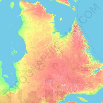
Name: Nord-du-Québec topographic map, elevation, terrain.

Location: Nord-du-Québec, Quebec, Canada (48.92653 -79.76287 62.58250 -63.31979)

Average elevation: 215 m

Minimum elevation: -1 m

Maximum elevation: 1,390 m

Other topographic maps

Click on a map to view its topography, its elevation and its terrain.

Mont Orford

Canada > Quebec > Memphrémagog > Orford

Average elevation: 559 m

Lac Letche

Canada > Quebec > Sept-Rivières > Lac-Walker

Average elevation: 689 m

Moore Creek

Canada > Quebec > Pontiac (MRC) > Otter Lake

Average elevation: 253 m

Sunny Bank

Canada > Quebec > La Côte-de-Gaspé > Gaspé

Average elevation: 63 m

Sherbrooke

Canada > Quebec > Sherbrooke

Average elevation: 249 m

George River

Canada > Quebec > Lac-Juillet

Average elevation: 493 m

Manicouagan

Canada > Quebec

Average elevation: 496 m

Baie Solitaire

Canada > Quebec > Rollet

Average elevation: 281 m

Mont Cole

Canada > Quebec > Argenteuil > Grenville-sur-la-Rouge

Average elevation: 260 m