
Williamson County topographic map
Interactive map
Click on the map to display elevation.
Williamson County
The area is divided into two regions by the Balcones Escarpment, which runs through the center from north to south along a line from Jarrell to Georgetown to Round Rock. The western half of the county is an extension of the Western Plains and is considered to be within the eastern fringes of Texas Hill Country; it has an average elevation of 850 feet (260 m). It features undulating, hilly brushland with an abundance of Texas live oak, prickly pear cactus, and karst topography. The eastern region of the county is part of the Coastal Plains and is flat to gently rolling with an average elevation of 600 feet (180 m). It consists of flatter land, with dark clay and rich, fertile soils for agriculture, but is quickly being developed as the county's population continues to increase and expand out. Williamson County is drained in the center and south by the San Gabriel River, which is the only river in the county, and in the north by creeks that run into the Lampasas and Little Rivers north of the county line.
About this map
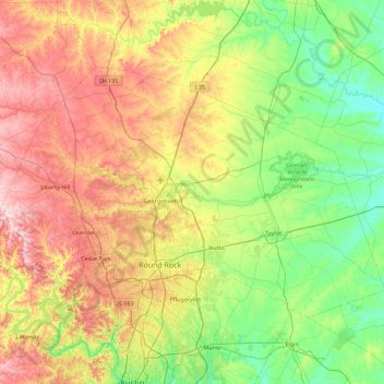
Name: Williamson County topographic map, elevation, terrain.
Location: Williamson County, Texas, United States (30.40281 -98.05005 30.90559 -97.15520)
Average elevation: 222 m
Minimum elevation: 110 m
Maximum elevation: 417 m
Other topographic maps
Click on a map to view its topography, its elevation and its terrain.
Georgetown
United States > Texas > Georgetown
The city is located on the northeastern edge of Texas Hill Country. Portions of Georgetown are located on either side of the Balcones Escarpment, a fault line in which the areas roughly east of IH-35 are flat and characterized by having black, fertile soils of the Blackland Prairie, and the west side of the…
Average elevation: 219 m
Bacliff
United States > Texas > Galveston County
After Hurricane Ike hit Texas in September 2008, Galveston County officials offered a debris removal program to residents in unincorporated areas, including Bacliff. Flooding from hurricane Ike was minimized due in part to Bacliff's relatively high elevation of 16 feet.
Average elevation: 4 m
Choke Canyon State Park - Calliham Unit
United States > Texas > McMullen County > Calliham
Average elevation: 67 m
Emory Peak
United States > Texas > Brewster County
The peak can be reached by a moderate hike on a well-marked path across steep rocky terrain with an elevation gain of approximately 2,500 feet (760 m). The Emory Peak Trail is about 1.5 miles (2.4 km) long. The trail is reached by climbing the Pinnacles Trail 3.5 miles (5.6 km) from the Chisos Basin trailhead.…
Average elevation: 2,061 m
Farnsworth
United States > Texas > Ochiltree County
Farnsworth is a census designated place in western Ochiltree County, Texas, United States. It lies at the intersection of State Highway 15 with FM376, southwest of the city of Perryton, the county seat of Ochiltree County. Its elevation is 2,995 feet (913 m). Although Farnsworth is unincorporated, it has a…
Average elevation: 913 m
Lower Rio Grande Valley National Wildlife Refuge
United States > Texas > Starr County > Rio Grande City
Average elevation: 50 m
San Luis Pass
United States > Texas > Galveston County > Galveston
Tides cause daily variations in topography, and occasionally, storms more drastically change the topography of the pass.
Average elevation: 0 m
Altamira West Number 2 Colonia
United States > Texas > Hidalgo County > Edinburg
Average elevation: 32 m
San Juan South Estates Colonia
United States > Texas > Hidalgo County > San Juan
Average elevation: 34 m
Soil Conservation Service Site 12 Dam
United States > Texas > Williamson County > Type
Average elevation: 173 m