
Lake Tana topographic map
Interactive map
Click on the map to display elevation.
Lake Tana
Lake Tana (also spelled T'ana, Amharic: ጣና ሀይቅ, Ṭana Ḥäyq, T’ana Hāyk’; an older variant is Tsana, Ge'ez: ጻና Ṣānā; sometimes called "Dembiya" after the region to the north of the lake) is the source of the Blue Nile and is the largest lake in Ethiopia. Located in Amhara Region in the north-western Ethiopian Highlands, the lake is approximately 84 kilometres (52 miles) long and 66 kilometres (41 miles) wide, with a maximum depth of 15 metres (49 feet), and an elevation of 1,788 metres (5,866 feet). Lake Tana is fed by the Gilgel Abay, Reb and Gumara rivers. Its surface area ranges from 3,000 to 3,500 square kilometres (1,200 to 1,400 square miles), depending on season and rainfall. The lake level has been regulated since the construction of the control weir where the lake discharges into the Blue Nile. This controls the flow to the Blue Nile Falls (Tis Abbai) and hydro-power station.
About this map
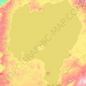
Name: Lake Tana topographic map, elevation, terrain.
Location: Lake Tana, Amhara Region, Ethiopia (11.59643 36.99544 12.30510 37.62224)
Average elevation: 1,829 m
Minimum elevation: 1,376 m
Maximum elevation: 2,394 m
Other topographic maps
Click on a map to view its topography, its elevation and its terrain.