Geolocate

Galway topographic map

Interactive map

Click on the map to display elevation.

About this map

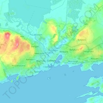
Name: Galway topographic map, elevation, terrain.

Location: Galway, County Galway, Connacht, Ireland (53.24852 -9.14269 53.31974 -8.95484)

Average elevation: 16 m

Minimum elevation: -3 m

Maximum elevation: 103 m

Other topographic maps

Click on a map to view its topography, its elevation and its terrain.

Dunmore

Ireland > County Galway

Dunmore, Tuam Municipal District, County Galway, Connacht, Ireland

Average elevation: 63 m

Athenry-Oranmore Municipal District

Ireland > County Galway

Athenry-Oranmore Municipal District, County Galway, Connacht, Ireland

Average elevation: 42 m

Taylor's Hill

Ireland > County Galway > Galway City

Taylor's Hill, Galway City, County Galway, Connacht, Ireland

Average elevation: 16 m

Menlo

Ireland > County Galway > Menlo

Menlo, County Galway, Connacht, H91 CF90, Ireland

Average elevation: 22 m

Galway City

Ireland > County Galway > Galway City

Galway City, County Galway, Connacht, Ireland

Average elevation: 15 m

Crowsnest

Ireland > County Galway

Crowsnest, Lismanny ED, Ballinasloe Municipal District, County Galway, Connacht, Ireland

Average elevation: 67 m