
Lembata Island topographic map
Interactive map
Click on the map to display elevation.
About this map
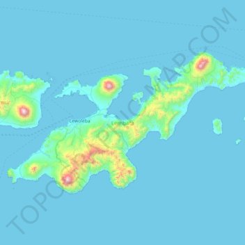
Name: Lembata Island topographic map, elevation, terrain.
Location: Lembata Island, Lembata, East Nusa Tenggara, Indonesia (-8.58576 123.20546 -8.17053 123.92423)
Average elevation: 70 m
Minimum elevation: 0 m
Maximum elevation: 1,595 m
Other topographic maps
Click on a map to view its topography, its elevation and its terrain.
Ili Ujolewung
Indonesia > East Nusa Tenggara > Lembata
Ili Ujolewung, Lembata, East Nusa Tenggara, Lesser Sunda Islands, Indonesia
Average elevation: 991 m