
Hoboken topographic map
Interactive map
Click on the map to display elevation.
About this map
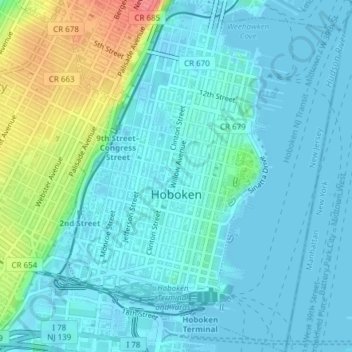
Name: Hoboken topographic map, elevation, terrain.
Location: Hoboken, Hudson County, New Jersey, United States (40.73039 -74.04399 40.75910 -74.01425)
Average elevation: 14 m
Minimum elevation: -2 m
Maximum elevation: 69 m
Other topographic maps
Click on a map to view its topography, its elevation and its terrain.
Jersey City
United States > New Jersey > Hudson County
Jersey City, Hudson County, New Jersey, United States
Average elevation: 9 m
Secaucus
United States > New Jersey > Hudson County
Secaucus, Hudson County, New Jersey, United States
Average elevation: 13 m
Jersey City
United States > New Jersey > Hudson County > Jersey City
Jersey City, Hudson County, New Jersey, 07302, United States
Average elevation: 21 m