
Nancy topographic map
Interactive map
Click on the map to display elevation.
About this map
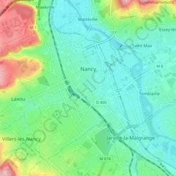
Name: Nancy topographic map, elevation, terrain.
Average elevation: 230 m
Minimum elevation: 187 m
Maximum elevation: 345 m
Other topographic maps
Click on a map to view its topography, its elevation and its terrain.
Praque
France > Grand Est > Meurthe-et-Moselle > Jouaville
Praque, Jouaville, Briey, Meurthe-et-Moselle, Grand Est, Metropolitan France, 54800, France
Average elevation: 256 m
Waville
France > Grand Est > Meurthe-et-Moselle > Waville
Waville, Briey, Meurthe-et-Moselle, Grand Est, Metropolitan France, 54890, France
Average elevation: 292 m
Tomblaine
France > Grand Est > Meurthe-et-Moselle > Tomblaine
Tomblaine, Nancy, Meurthe-et-Moselle, Grand Est, Metropolitan France, 54510, France
Average elevation: 206 m
Frolois
France > Grand Est > Meurthe-et-Moselle
Frolois, Nancy, Meurthe-et-Moselle, Grand Est, Metropolitan France, 54160, France
Average elevation: 272 m