
Eindhoven topographic map
Interactive map
Click on the map to display elevation.
About this map
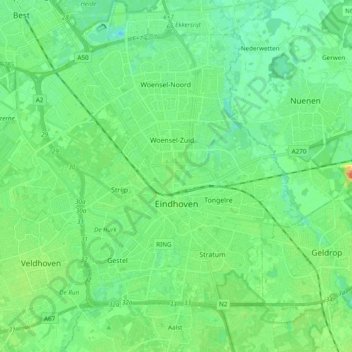
Name: Eindhoven topographic map, elevation, terrain.
Location: Eindhoven, North Brabant, Netherlands (51.40005 5.35672 51.49708 5.54885)
Average elevation: 20 m
Minimum elevation: 6 m
Maximum elevation: 54 m
Other topographic maps
Click on a map to view its topography, its elevation and its terrain.
's-Hertogenbosch
Netherlands > North Brabant > 's-Hertogenbosch
's-Hertogenbosch, North Brabant, Netherlands
Average elevation: 4 m
Drunen
Netherlands > North Brabant > Drunen
Drunen, Heusden, North Brabant, Netherlands
Average elevation: 6 m
Udenhout
Netherlands > North Brabant > Udenhout
Udenhout, Tilburg, North Brabant, Netherlands
Average elevation: 10 m
Veldhoven
Netherlands > North Brabant > Veldhoven
Veldhoven, North Brabant, Netherlands
Average elevation: 23 m
Mill
Netherlands > North Brabant > Mill en Sint Hubert
Mill, Mill en Sint Hubert, North Brabant, Netherlands
Average elevation: 14 m
Koks
Netherlands > North Brabant > Koks
Koks, North Brabant, Netherlands, 5421, Netherlands
Average elevation: 15 m
Riethoven
Netherlands > North Brabant > Bergeijk
Riethoven, Bergeijk, North Brabant, Netherlands
Average elevation: 26 m
Zundert
Netherlands > North Brabant > Zundert
Zundert, North Brabant, Netherlands
Average elevation: 11 m