
Make a donation
Gear up for your next adventure:
As an Amazon Associate, this site earns from qualifying purchases at no extra cost to you.
Milsbeek topographic map
Click on the map to display elevation.
Make a donation
Gear up for your next adventure:
As an Amazon Associate, this site earns from qualifying purchases at no extra cost to you.
Milsbeek
Milsbeek ligt in de vallei van de Maas, op een hoogte van ongeveer 12 meter. Eerder lag er langs de Maas een steenfabriek die van 1898-2008 in werking was. Naar het noorden toe ligt er een vlak en door ruilverkavelingen grootschalig stuk land dat naar het noorden toe scherp begrensd wordt door de stuwwallen van de Sint-Jansberg en het Reichswald. Naar het westen toe vindt men de Mookerplas en in het zuiden ligt de monding van de Niers, die hier in de Maas uitmondt.
Make a donation
Gear up for your next adventure:
As an Amazon Associate, this site earns from qualifying purchases at no extra cost to you.
About this map
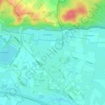
Name: Milsbeek topographic map, elevation, terrain.
Location: Milsbeek, Gennep, Limburg, Nederland (51.71344 5.91947 51.74802 5.97570)
Average elevation: 20 m
Minimum elevation: 4 m
Maximum elevation: 71 m
Make a donation
Gear up for your next adventure:
As an Amazon Associate, this site earns from qualifying purchases at no extra cost to you.
Other topographic maps
Click on a map to view its topography, its elevation and its terrain.