Geolocate

Vijlen topographic map

Interactive map

Click on the map to display elevation.

About this map

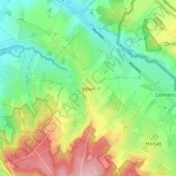
Name: Vijlen topographic map, elevation, terrain.

Location: Vijlen, Limburg, Nederland, 6294, Nederland (50.76781 5.94438 50.80781 5.98438)

Average elevation: 180 m

Minimum elevation: 118 m

Maximum elevation: 278 m

Other topographic maps

Click on a map to view its topography, its elevation and its terrain.

Camerig

Nederland > Limburg > Vijlen

Camerig, Vijlen, Vaals, Limburg, Nederland, 6294 NB, Nederland

Average elevation: 166 m

Rott

Nederland > Limburg > Vijlen > Rott

Rott, Vijlen, Vaals, Limburg, Nederland, 6294, Nederland

Average elevation: 167 m

Cottessen

Nederland > Limburg > Vijlen

Cottessen, Vijlen, Vaals, Limburg, Nederland, 6294 NE, Nederland

Average elevation: 183 m

Harles

Nederland > Limburg > Vijlen

Harles, Vijlen, Vaals, Limburg, Nederland, 6294 NG, Nederland

Average elevation: 194 m