
Walem topographic map
Interactive map
Click on the map to display elevation.
About this map
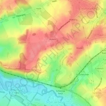
Name: Walem topographic map, elevation, terrain.
Location: Walem, Valkenburg aan de Geul, Limburg, Nederland (50.85691 5.86176 50.87300 5.87343)
Average elevation: 115 m
Minimum elevation: 71 m
Maximum elevation: 148 m
Other topographic maps
Click on a map to view its topography, its elevation and its terrain.
Houthem
Nederland > Limburg > Valkenburg aan de Geul > Houthem
Houthem, Valkenburg aan de Geul, Limburg, Nederland, 6301, Nederland
Average elevation: 105 m
Goudsberg
Nederland > Limburg > Valkenburg aan de Geul
Goudsberg, Valkenburg aan de Geul, Limburg, Nederland, 6301RH, Nederland
Average elevation: 115 m