
Erkelenz topographic map
Interactive map
Click on the map to display elevation.
About this map
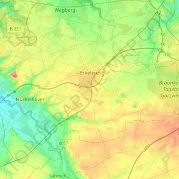
Name: Erkelenz topographic map, elevation, terrain.
Location: Erkelenz, Kreis Heinsberg, Noordrijn-Westfalen, 41812, Duitsland (51.01265 6.20069 51.11704 6.47742)
Average elevation: 83 m
Minimum elevation: 42 m
Maximum elevation: 150 m
Other topographic maps
Click on a map to view its topography, its elevation and its terrain.
Holzweiler
Duitsland > Noordrijn-Westfalen > Kreis Heinsberg > Erkelenz
Holzweiler, Erkelenz, Kreis Heinsberg, Noordrijn-Westfalen, Duitsland
Average elevation: 96 m