
Schoonbron topographic map
Interactive map
Click on the map to display elevation.
About this map
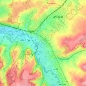
Name: Schoonbron topographic map, elevation, terrain.
Average elevation: 121 m
Minimum elevation: 71 m
Maximum elevation: 173 m
Other topographic maps
Click on a map to view its topography, its elevation and its terrain.
Oud-Valkenburg
Nederland > Limburg > Schin op Geul
Oud-Valkenburg, Schin op Geul, Valkenburg aan de Geul, Limburg, Nederland, 6305 AB, Nederland
Average elevation: 117 m
Engwegen
Nederland > Limburg > Schin op Geul
Engwegen, Schin op Geul, Valkenburg aan de Geul, Limburg, Nederland, 6305 PM, Nederland
Average elevation: 120 m