Geolocate

Langbroek topographic map

Interactive map

Click on the map to display elevation.

About this map

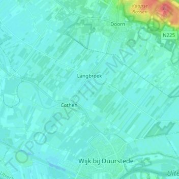
Name: Langbroek topographic map, elevation, terrain.

Location: Langbroek, Wijk bij Duurstede, Utrecht, Nederland (51.98385 5.29122 52.02700 5.41528)

Average elevation: 7 m

Minimum elevation: -4 m

Maximum elevation: 62 m

Other topographic maps

Click on a map to view its topography, its elevation and its terrain.

Wijk bij Duurstede

Nederland > Utrecht > Wijk bij Duurstede

Wijk bij Duurstede, Utrecht, Nederland

Average elevation: 5 m

Cothen

Nederland > Utrecht > Wijk bij Duurstede

Cothen, Wijk bij Duurstede, Utrecht, Nederland

Average elevation: 5 m

Kasteel Duurstede

Nederland > Utrecht > Wijk bij Duurstede

Kasteel Duurstede, Langs de Wal, Binnenstad, Wijk bij Duurstede, Utrecht, Nederland, 3961BD, Nederland

Average elevation: 6 m