Geolocate

Vielsalm topographic map

Click on the map to display elevation.

About this map

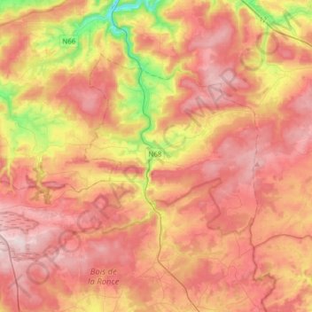
Name: Vielsalm topographic map, elevation, terrain.

Location: Vielsalm, Bastogne, Luxembourg, Wallonia, Belgium (50.21891 5.70967 50.34830 6.01728)

Average elevation: 472 m

Minimum elevation: 243 m

Maximum elevation: 630 m

Gear up for your next adventure:

🚴Cycling Backpacks - Backpacks for cyclists
🧰Survival Kits - Essential survival gear
🎒Hiking Backpacks - Backpacks designed for hiking and trekking
🎒Ultralight Backpacks - Lightweight packs for long hikes
Altimeter Barometer Watches - Outdoor watches with built-in sensors to track altitude changes and weather shifts

As an Amazon Associate, this site earns from qualifying purchases at no extra cost to you.