
Fortaleza topographic map
Interactive map
Click on the map to display elevation.
About this map
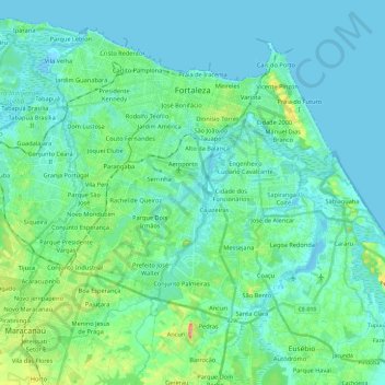
Name: Fortaleza topographic map, elevation, terrain.
Average elevation: 19 m
Minimum elevation: -2 m
Maximum elevation: 111 m
Other topographic maps
Click on a map to view its topography, its elevation and its terrain.
Monsenhor Tabosa
Brazil > Ceará > Monsenhor Tabosa
Monsenhor Tabosa, Região Geográfica Imediata de Crateús, Região Geográfica Intermediária de Crateús, Ceará, Northeast Region, Brazil
Average elevation: 529 m
Sítio Norte
Brazil > Ceará > Alcântaras > Sítio Norte
Sítio Norte, Alcântaras, Região Geográfica Imediata de Sobral, Região Geográfica Intermediária de Sobral, Ceará, Northeast Region, Brazil
Average elevation: 806 m
Pedra Branca
Brazil > Ceará > Pedra Branca
Pedra Branca, Microrregião o Sertão de Senador Pompeu, Mesorregião dos Sertões Cearenses, Ceará, Northeast Region, Brazil
Average elevation: 405 m