
North Brabant topographic map
Interactive map
Click on the map to display elevation.
About this map
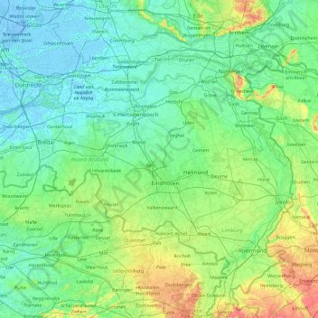
Name: North Brabant topographic map, elevation, terrain.
Location: North Brabant, Netherlands (51.22091 4.19012 51.83075 6.04812)
Average elevation: 22 m
Minimum elevation: -7 m
Maximum elevation: 158 m
The historical region of Kempen occupies the southern part of the province of Noord-Brabant and extends south of Eindhoven far into northern Belgium. To the east it reaches as far as the Meuse valley. The surface topography of De Kempen is very uniform. Most of it lies between 5 m (15 ft) and 35 m (115 ft) above sea level. The basement rocks are Cretaceous and Tertiary sediments, which are overlaid by Ice Age gravels and sands carried here by rivers of melt-water from the retreating glaciers. It is a typical area of sandy heathland. The infertile soil is suitable only for undemanding crops such as rye, oats, potatoes and fodder plants; this limits the profitability of agriculture. Until a few decades ago Kempen was a region of heathland and sand drifts with a sparse growth of pines, a few scattered villages subsisting on the poor soil and some small towns; and this is still the pattern in much of the region. In recent years, however, the rapid advance of industry has brought about profound changes in this agricultural region. The origins of this industrial development go back 70–100 years. The main concentrations of industry are along the southern frontier of the Netherlands, e.g., at Eindhoven, Helmond, Tilburg, Breda, 's-Hertogenbosch.
Other topographic maps
Click on a map to view its topography, its elevation and its terrain.
Noordoostpolder
Noordoostpolder, Flevoland, Netherlands
Average elevation: -1 m
Boskoop
Boskoop, Alphen aan den Rijn, South Holland, Netherlands
Average elevation: -2 m
Eiland van Bèr
Netherlands > Limburg > Maastricht
Eiland van Bèr, Maastricht, Limburg, Netherlands, 6212 NE, Netherlands
Average elevation: 137 m
Gorinchem
Netherlands > South Holland > Gorinchem
Gorinchem, South Holland, Netherlands
Average elevation: 1 m
Spijkenisse
Spijkenisse, Nissewaard, South Holland, Netherlands
Average elevation: 1 m
Twente
Netherlands > Overijssel > Saasveld
Twente, Saasveld, Dinkelland, Overijssel, Netherlands, 7597 KL, Netherlands
Average elevation: 36 m
Zeewolde
Netherlands > Flevoland > Zeewolde
Zeewolde, Flevoland, Netherlands, Zeewolde
Average elevation: -2 m
Warmenhuizen
Warmenhuizen, Schagen, North Holland, Netherlands
Average elevation: 0 m
Badhoevedorp
Badhoevedorp, Haarlemmermeer, North Holland, Netherlands
Average elevation: -2 m
Zwarte Water
Netherlands > Overijssel > Zwolle
Zwarte Water, Binnenstad, Zwolle, Overijssel, Netherlands, 8031 ES, Netherlands
Average elevation: 4 m
Purmerend
Netherlands > North Holland > Purmerend
Purmerend, North Holland, Netherlands
Average elevation: -2 m
's-Hertogenbosch
Netherlands > North Brabant > 's-Hertogenbosch
's-Hertogenbosch, North Brabant, Netherlands
Average elevation: 4 m
Amsterdam
Netherlands > North Holland > Amsterdam
Amsterdam, North Holland, Netherlands, 1012JS, Netherlands
Average elevation: -1 m
Vlaardingen
Netherlands > South Holland > Vlaardingen
Vlaardingen, South Holland, Netherlands
Average elevation: 1 m
Hoogvliet Rotterdam
Netherlands > South Holland > Hoogvliet Rotterdam
Hoogvliet Rotterdam, Rotterdam, South Holland, Netherlands
Average elevation: 2 m
Drunen
Netherlands > North Brabant > Drunen
Drunen, Heusden, North Brabant, Netherlands
Average elevation: 6 m
Hoofddorp
Netherlands > North Holland > Hoofddorp
Hoofddorp, Haarlemmermeer, North Holland, Netherlands
Average elevation: -3 m
Udenhout
Netherlands > North Brabant > Udenhout
Udenhout, Tilburg, North Brabant, Netherlands
Average elevation: 10 m
Haarlem
Netherlands > North Holland > Haarlem
Haarlem, North Holland, Netherlands
Average elevation: 3 m
Leeward Islands
Leeward Islands, Zion's Hill, Saba, Netherlands
Average elevation: 112 m
Capelle aan den IJssel
Capelle aan den IJssel, South Holland, Netherlands
Average elevation: -1 m
Veldhoven
Netherlands > North Brabant > Veldhoven
Veldhoven, North Brabant, Netherlands
Average elevation: 23 m
Vasse
Netherlands > Overijssel > Vasse
Vasse, Overijssel, Netherlands, 7661, Netherlands
Average elevation: 42 m