
Capelle aan den IJssel topographic map
Interactive map
Click on the map to display elevation.
About this map
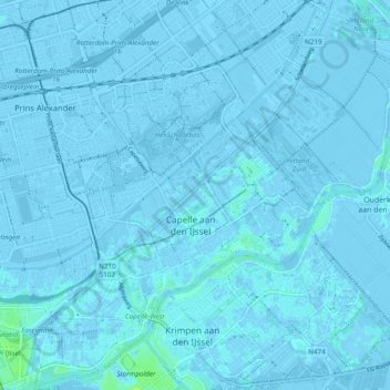
Name: Capelle aan den IJssel topographic map, elevation, terrain.
Location: Capelle aan den IJssel, South Holland, Netherlands (51.90620 4.53716 51.96550 4.61949)
Average elevation: -1 m
Minimum elevation: -7 m
Maximum elevation: 15 m
Dutch Topographic map of the municipality of Capelle aan den IJssel, June 2015.
Other topographic maps
Click on a map to view its topography, its elevation and its terrain.
Boskoop
Boskoop, Alphen aan den Rijn, South Holland, Netherlands
Average elevation: -2 m
Gorinchem
Netherlands > South Holland > Gorinchem
Gorinchem, South Holland, Netherlands
Average elevation: 1 m
Spijkenisse
Spijkenisse, Nissewaard, South Holland, Netherlands
Average elevation: 1 m
Vlaardingen
Netherlands > South Holland > Vlaardingen
Vlaardingen, South Holland, Netherlands
Average elevation: 1 m
Hoogvliet Rotterdam
Netherlands > South Holland > Hoogvliet Rotterdam
Hoogvliet Rotterdam, Rotterdam, South Holland, Netherlands
Average elevation: 2 m
Katwijk
Netherlands > South Holland > Katwijk
Katwijk, South Holland, Netherlands
Average elevation: 3 m
Noordwijk
Netherlands > South Holland > Noordwijk
Noordwijk, South Holland, Netherlands
Average elevation: 1 m
Monster
Netherlands > South Holland > Monster > Monster
Monster, Westland, South Holland, Netherlands, 2681, Netherlands
Average elevation: 1 m
Zoetermeer
Netherlands > South Holland > Zoetermeer
Zoetermeer, South Holland, Netherlands
Average elevation: -3 m