
Schiedam topographic map
Interactive map
Click on the map to display elevation.
About this map
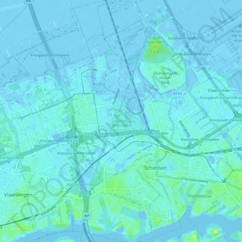
Name: Schiedam topographic map, elevation, terrain.
Location: Schiedam, Zuid-Holland, Nederland (51.89668 4.35067 51.96341 4.41771)
Average elevation: 1 m
Minimum elevation: -8 m
Maximum elevation: 14 m
Other topographic maps
Click on a map to view its topography, its elevation and its terrain.
Windas
Nederland > Zuid-Holland > Schiedam
Windas, Schiedam, Zuid-Holland, Nederland, 3121 KL, Nederland
Average elevation: 1 m