
Stevensweert topographic map
Interactive map
Click on the map to display elevation.
About this map
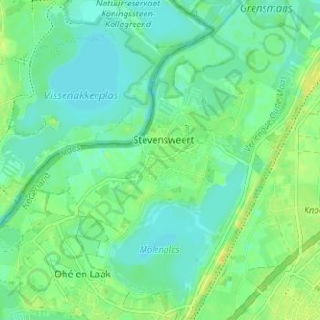
Name: Stevensweert topographic map, elevation, terrain.
Location: Stevensweert, Maasgouw, Limburg, Nederland (51.10911 5.81870 51.14833 5.87272)
Average elevation: 25 m
Minimum elevation: 17 m
Maximum elevation: 36 m
De hoogte van Stevensweert bedraagt ongeveer 23 meter.
Other topographic maps
Click on a map to view its topography, its elevation and its terrain.
Bilt
Nederland > Limburg > Stevensweert
Bilt, Stevensweert, Maasgouw, Limburg, Nederland, 6107 BM, Nederland
Average elevation: 25 m