
Houten topographic map
Interactive map
Click on the map to display elevation.
About this map
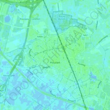
Name: Houten topographic map, elevation, terrain.
Location: Houten, Utrecht, Nederland (52.00455 5.12177 52.05676 5.20353)
Average elevation: 2 m
Minimum elevation: -4 m
Maximum elevation: 6 m
De volgende straten, lanen, pleinen, parken en andere topografische aanduidingen hebben een eigen artikel op Wikipedia:
Other topographic maps
Click on a map to view its topography, its elevation and its terrain.
Oud-Wulven
Oud-Wulven, Houten, Utrecht, Nederland, 3992 AA, Nederland
Average elevation: 3 m
Tull en 't Waal
Tull en 't Waal, Houten, Utrecht, Nederland
Average elevation: 2 m