
Make a donation
Gear up for your next adventure:
As an Amazon Associate, this site earns from qualifying purchases at no extra cost to you.
Nuth topographic map
Click on the map to display elevation.
Make a donation
Gear up for your next adventure:
As an Amazon Associate, this site earns from qualifying purchases at no extra cost to you.
Nuth
Nuth ligt op de helling die van het Geleenbeekdal naar het Centraal Plateau voert. De kerk ligt op ongeveer 85 meter hoogte. Ten noorden van Nuth loopt de Platsbeek in oostelijke richting. Nuth is uitgegroeid tot een betrekkelijk grote plaats met tevens enkele uitgestrekte bedrijventerreinen.
Make a donation
Gear up for your next adventure:
As an Amazon Associate, this site earns from qualifying purchases at no extra cost to you.
About this map
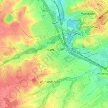
Name: Nuth topographic map, elevation, terrain.
Location: Nuth, Limburg, Nederland, 6361, Nederland (50.89567 5.86610 50.93567 5.90610)
Average elevation: 95 m
Minimum elevation: 61 m
Maximum elevation: 129 m
Make a donation
Gear up for your next adventure:
As an Amazon Associate, this site earns from qualifying purchases at no extra cost to you.