
Make a donation
Gear up for your next adventure:
As an Amazon Associate, this site earns from qualifying purchases at no extra cost to you.
Montanha topographic map
Click on the map to display elevation.
Make a donation
Gear up for your next adventure:
As an Amazon Associate, this site earns from qualifying purchases at no extra cost to you.
About this map
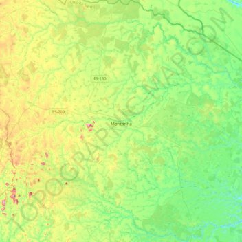
Name: Montanha topographic map, elevation, terrain.
Average elevation: 181 m
Minimum elevation: 31 m
Maximum elevation: 510 m
Make a donation
Gear up for your next adventure:
As an Amazon Associate, this site earns from qualifying purchases at no extra cost to you.
Other topographic maps
Click on a map to view its topography, its elevation and its terrain.
Make a donation
Gear up for your next adventure:
As an Amazon Associate, this site earns from qualifying purchases at no extra cost to you.
Pico da Bandeira
Brazil > Espírito Santo > Ibitirama
Pico da Bandeira is also remarkable for being the Brazilian mountain with the greatest topographic isolation: 2,344 km (1,457 miles). This means that at less than that distance, there is no other point on the surface of the Earth at equal or greater elevation. In the Americas, only Aconcagua, Denali, Pico de…
Average elevation: 2,488 m
Make a donation
Gear up for your next adventure:
As an Amazon Associate, this site earns from qualifying purchases at no extra cost to you.